As an uncontrolled “super fire” near Colorado Springs rages, feeding off parched terrain and forcing tens of thousands from their homes and businesses, high-tech mapping tools are dishing up highly detailed, bird’s eye views of the fire’s scope.
Such tools offer everything from perimeter reports and pictures of the devastation to evacuation areas and shelters for both people and pets in the fire’s path.
(PHOTOS: Wildfires Whip Through Colorado)
Visit something called Google Crisis Response — an official Google website designed “to make critical information more accessible around natural disasters and humanitarian crises” — and you’ll find a Google Crisis Map of 2012 wildfires stippled with bright red and yellow markers signifying environmental flashpoints around the country.
There’s one southwest of Spearfish, South Dakota, for instance: a fire started by lightning that’s grown to 125 acres and has some 170 people, including helicopters, fire engines and bulldozers, working to contain it. It’s currently listed as 65% contained.
And there’s another spread across over 46,000 acres near Mt. Pleasant, Utah that’s so far consumed 56 structures, forced evacuations of multiple rural areas and killed one civilian. It’s listed as only 15% contained as of Wednesday morning.
Mapping the Colorado ‘Super Fire’
Hover over Colorado on the map and you’ll find a state awash in red and orange, with additional alert markers indicating recovery centers and shelters for both humans and animals. If you drill down on Colorado Springs itself, to a zoom level of one mile, your screen fills with a red jag-line outlining the Waldo Canyon fire currently grabbing news headlines.
It’s been referred to as a “super fire” because of the area’s extremely dry conditions, which coupled with high-speed winds — up to 60 mph — cause the flames to hurtle from treetop to treetop and burn so hot that firefighters can’t get close.
It’s forced some 32,000 people to evacuate so far (and likely more, since precise evacuation numbers are unknown). The fire overlays more than 15,000 acres, according to Google’s map, and it’s listed as only 5% contained. That’s serious enough, given its proximity to such a major residential area, that President Obama plans to visit the region today.
Zoom in further on Google’s crisis map and you can pinpoint where the fire line has moved east out of the “green” area, near Hurricane Canyon Natural Area and popular tourist spots like Garden of the Gods and Cave of the Winds. It’s moved into West Colorado Springs, touching Woodmen Road near Woodmen-Roberts Elementary School and crossing Flying West Ranch Road in several places, enveloping residential zones (and dozens of streets) as well as various businesses listed on the map.
Click anywhere within the red zone and Google indicates the mapping data was created using the USFS infrared imaging program (NIROPS). It’s sourced from the State of Colorado Division of Emergency Management, which maintains a Google Map of active fires across the state and updates the map “each morning and as needed throughout the day as new information is available.”
Crowdsourced Cartography
But it’s on a map of the area created and maintained by a company called Esri that things get really interesting. Esri keeps tabs on wildfires across the U.S., too, but combines its information with crowdsourced information gleaned from social networking and video sharing sites.
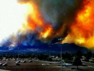
Esri’s wildfire map — that’s a shot of the Waldo Canyon fire taken from it up top — is much more detailed than Google’s. It offers multiple ways of drilling on impacted areas, including a topographic option that shows height contour levels as well as multiple layering options that let you check stuff like wildfire perimeters, current wind conditions, scan RSS news feeds related to the flashpoint, monitor precipitation and estimate wildfire potential based on environmental conditions.
Click the “social” tab on Esri’s menubar and you’ll discover the option to overlay social media services like Flickr, Twitter and YouTube. Pick something from the biggest Twitter cluster — a mammoth green dot superimposed over Colorado Springs and sized in proportion to the number of updates — and you’ll discover curated, crowdsourced tweets with links to information like a NASA aerial photo of the Waldo Canyon fire as seen from space.
Another tweet posted Thursday morning indicated the fire had grown to 18,000 acres (3,000 more than Google Maps was reporting; Eris itself had the Waldo Canyon fire at 18,500 acres Thursday morning). This map-based image of the fire’s startling progression between June 23 and June 26 was uploaded by local Colorado Springs news station KKTV 11.
Scroll around and you’ll find user-filmed and uploaded YouTube videos of the fire from various angles around the area, many depicting giant plumes of white or dark gray smoke obscuring the horizon and rising into clouds framed by a strikingly blue sky.
(WATCH: Four Harrowing Videos of Colorado’s Waldo Canyon Fire)
In other words, by combining the sort of official governmental information a source like Google Maps uses with more frequently updated, crowdsourced information, Esri can offer a more nuanced (if not always as accurate, depending on an information-giver’s contextualization) picture of what’s happening in a fast-changing crisis zone.
The Waldo Canyon Wildfire Tracker
A third way to keep tabs on the Waldo Canyon wildfire, and one that emerged just as the fire was capturing national headlines, is something called the Waldo Canyon Wildfire Tracker, an “app” designed by a pair of nearby programmers to collate messages and photos about the fire. I put scare quotes around “app” because it’s actually a web page that tracks a handful of key terms in Twitter, then posts those tweets on the page in real time.

@timring3TV
As I was scanning the feed, several caught my eye:
“So sad to see… so many memories here… I proposed at this lake…” wrote Twitter user @kevingoro, including shots of the lake engulfed by smoke.
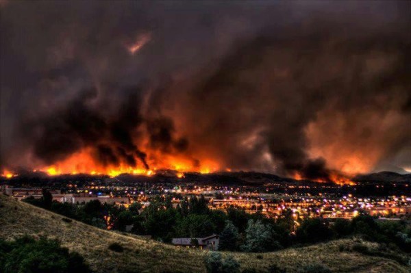
Another Twitter user, @timring3TV, posted a “breathtaking photo” of the area near the Air Force Academy (just north of Colorado Springs) showing the foothills aflame as an orange-red, black cloud dominates the skyline (that’s it, shown at right).
(MORE: How a Common Sandbox Is Battling Arizona’s Wallow Fire)
And a tweet on June 27 from @CSFDPIO, a feed operated by the Colorado Springs Fire Dept Public Information Unit, listed figures related to the wildfire: “18,500 acres; 5% containment; 1000 personnel; 500 Sheriff/PD; 27 crews; 73 engines; 3 water tenders; 0 injuries.”
The photo gallery at the top of the tracker’s webpage is what makes this tracker unique, folding in wildfire-related pictures as they’re posted to Twitter, including devastating shots like this one, uploaded by popular Denver band @OneRepublic:

@OneRepublic
For Your Mobile
If you’re in the market for an actual phone or tablet app, a quick scan of the Apple App Store unearthed a free tool called Wildfire Info. The app provides “detailed wild land fire incident information” from FireWhat.com, offering roughly the same officially sourced information available from sites like Google Maps and Eris, either telling you what’s happening near you, based on GPS information, or allowing you to pick from a list sorted by state.
When I brought up Colorado, I scrolled through over a dozen incidents before I found the Waldo Canyon fire, where the app gave me the fire’s reported size (18,500 acres — last updated the evening of June 27), its containment (5%), its latitude and longitude and the option to view it on a map with standard and satellite views.
There’s actually a Pro version for $4.99 available for both iOS and Android devices that claims to offer active fire perimeter mapping, fire calculators (that use Weather and FDFM/PIG), quick reference guides for various report types (Safety, Weather, Operations and Size Up) fire maps with custom overlays (including severe weather) and NEXRAD radar.
And last but not least, if you want to keep tabs on official Twitter feeds, don’t forget the Colorado Division of Emergency Management, which is “responsible for all-hazards preparedness, prevention, response and recovery.” Its Twitter feed, @COEmergency, has been keeping readers posted about crew activities, evacuee registration info and what’s needed, from wire animal crates to waste bags and watering cans.
MORE: Review: The Weather Channel’s Slick New (and Free) iPhone App

