

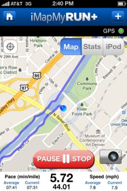
Keeping track of your daily run — especially if, like me, you prefer to run outdoors during the warmer months — can be a chore if you’re trying to gauge distances along new routes. I discovered the website MapMyRUN a couple years ago and used it to manually plot distances with its point-to-point Google Maps overlay. Until I discovered the iPhone version, that is — a free exercise tracker that combines your iPhone’s GPS with Google Maps to automatically plot your running routes live. It includes your current/average speed, the route’s total elevation, a button to snap landmark photos along the way and the option to pause or start tracking with a tap, say you’re paused at a traffic light. Better still, this ad-free logger includes a nutrition tracker that lets you keep track of how many calories you’re eating.
Link: iMapMyRUN+